Best Hiking Trails in Europe: 17 Top Routes and Tips
Europe’s top hiking areas combine well-marked trails, dramatic landscapes, and strong safety infrastructures. Below, you’ll find specific routes, typical durations and difficulty levels, prime seasons, and practical advice sourced from park authorities and established guide networks. Use this to choose the right objective for your fitness, experience, and gear.
- Best Hiking Trails in Europe: 17 Top Routes and Tips
- 17 Epic hiking trails in Europe
- Caucasus Mountains (Georgia)
- West Highland Way – Scotland, UK
- Mount Triglav – Slovenia
- Via Dinarica – Western Balkans
- Tour de Monte Rosa – Italy, Switzerland
- Laugavegur Trail – Iceland
- High Tatras – Slovakia, Poland
- Dolomites – Italy
- Tour du Mont Blanc – France, Italy, Switzerland
- Plitvice Lakes National Park – Croatia
- Alpe Adria Trail – Austria, Slovenia, Italy
- Pennine Way – England, UK
- Hadrian’s Wall Path – England, UK
- Snowdonia/Eryri – Wales, UK
- Wicklow Way – Ireland
- Kerry Way – Ireland
- Causeway Coast Way – Northern Ireland
- Responsible hiking checklist
- How we selected these hikes
17 Epic hiking trails in Europe
For my son, the true soul of Europe isn’t found in its crowded squares, but on its ancient paths, high passes, and coastal cliffs. If you too hear the call of the trail, here are 17 legendary walks that have shaped his dreams and filled many notebooks.
Caucasus Mountains (Georgia)
Trek through the wild, towering peaks of Georgia or Svaneti, where ancient stone watchtowers stand guard over pristine valleys and formidable glaciers.

What to hike
The Mestia–Ushguli trek in Upper Svaneti (4 days; ~60–75 km depending on variants) links medieval stone villages beneath glaciated peaks. In Kazbegi, the Gergeti Glacier and Truso Valley are popular day hikes.
Difficulty
Moderate, with occasional steep, muddy sections and stream crossings. Prime season: June–September.
Safety and logistics
Weather can shift fast; carry rain gear and trekking poles for crossings. Guesthouses offer meals and transfers; no permits are required for the main routes, but always confirm local conditions in Mestia.
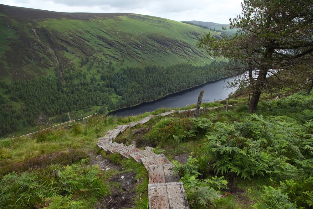
West Highland Way – Scotland, UK
From the outskirts of Glasgow into the heart of the Highlands—lonely lochs, moody moors, and the grand finale beneath Ben Nevis

A 154 km National Trail from Milngavie to Fort William. Typical time: 6–8 days. Terrain: well-waymarked paths through lochs, moorland, and glens.
What to hike
Classic stages include Conic Hill and Loch Lomond shores (Milngavie–Balmaha/Rowardennan), Crianlarich/Tyndrum to Bridge of Orchy, the Rannoch Moor crossing to Kingshouse, Devil’s Staircase to Kinlochleven, and the final Lairigmor into Fort William. Shorter options: day-hike Conic Hill or the Kingshouse–Kinlochleven section.
Difficulty
Moderate; cumulative ascent can be taxing. Prime season: May–September (expect midges; bring repellent or head net).
Logistics
Book accommodation in advance; baggage transfer services are common. Wild camping is legal with Leave No Trace practices.
Mount Triglav – Slovenia
A national rite of passage, summiting this three-headed peak involves exciting via ferrata sections and rewards you with panoramic Julian Alps views.

What to hike
Slovenia’s highest peak (2,864 m) in Triglav National Park. Standard ascent is a 2-day outing via mountain huts (e.g., Kredarica), with via ferrata sections on the summit ridge.
Difficulty
Moderate to strenuous; exposure requires via ferrata kit (helmet, harness, lanyards). Prime season: July–September.
Logistics
Reserve huts in advance; guided ascents available and recommended for first-time climbers.
Via Dinarica – Western Balkans
Traverse the dramatic limestone landscapes of the Dinaric Alps, a long-distance trail revealing the raw beauty and complex history of the Balkans.

What to Hike
A long-distance route network (~1,930 km across White/Green/Blue Trails) spanning Slovenia, Croatia, Bosnia & Herzegovina, Montenegro, and Albania. Highlights include karst plateaus, limestone peaks, and remote villages.
Difficulty
Varies widely; expect sections with limited waymarking and services. Best approach: Tackle segments (e.g., Croatia’s Velebit, Bosnia’s Prenj) rather than the full route unless you’re experienced with multi-week thru-hikes.
Logistics
Carry sufficient water on karst terrain; confirm huts and resupply points ahead of time.
Tour de Monte Rosa – Italy, Switzerland
This high-altitude circuit offers more solitude than its famous neighbour, circling one of Europe’s largest mountains with staggering views of immense glacial faces.

What to hike
A high-level circuit around the Monte Rosa massif linking valleys like Zermatt and Gressoney. Typical length: ~165–170 km; 8–11 days.
Difficulty
Strenuous with big elevation changes and occasional glacier-adjacent terrain (no technical climbing on the standard trek). Prime season: July–September.
Logistics
Book huts and small inns; be prepared for altitude (multiple passes >2,700 m) and sudden storms.
Laugavegur Trail – Iceland
It feels like hiking across another planet. In 4-5 days, you pass rainbow mountains, obsidian deserts, glacial rivers, and steaming hot springs.
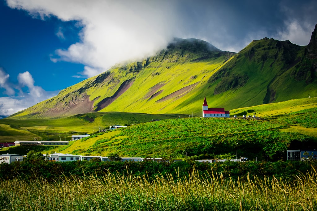
What to hike
Iceland’s best-known multi-day trek from Landmannalaugar to Þórsmörk (~55 km; 3–4 days), famous for geothermal areas, rhyolite mountains, and black sand deserts.
Difficulty
Moderate to strenuous; multiple river fords, frequent high winds and rain. Prime season: Late June–early September.
Logistics
Mountain huts must be booked early; camping allowed at designated sites. Carry warm layers and waterproofs even in summer.
High Tatras – Slovakia, Poland
Experience the sheer, alpine drama of Central Europe’s most rugged range, where sharp granite spires tower above emerald lakes and well-maintained trails.

What to hike
The Tatranská magistrála (red trail) is a classic multi-day traverse on the Slovak side, linking lakes like Štrbské pleso and Popradské pleso. Shorter day hikes lead to alpine huts and waterfalls.
Difficulty
Easy to moderate on marked trails; true summits often require a certified guide (especially on the Polish side). Prime season: June–October, with snow lingering early/late.
Logistics
Use cable cars and mountain hotels to shorten approaches. Weather shifts quickly; start early and confirm hut openings.
Dolomites – Italy
Hike amidst a UNESCO-listed fantasy of pale, towering spires, via ferratas, and lush meadows, where every turn reveals a view more breathtaking than the last.
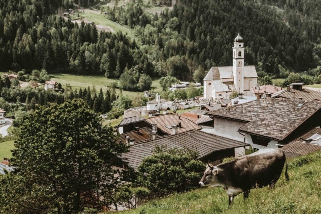
What to hike
Alta Via 1 (120 km; 7–10 days) and Alta Via 2 are classic hut-to-hut treks. Day options include Tre Cime di Lavaredo and Seceda ridgeline. WWII-era via ferrata routes offer protected scrambling for equipped hikers.
Difficulty
Easy day hikes to strenuous multi-day traverses; via ferrata require specialized gear and training. Prime season: Late June–September.
Logistics
Reserve rifugi (mountain huts) well in advance.
Tour du Mont Blanc – France, Italy, Switzerland
The iconic alpine circuit. Imagine a 170-km carousel around the roof of Europe, where every turn serves a new majestic peak, and your sleep is in cozy refuges.

What to hike
The Tour du Mont Blanc (TMB) is a non-technical circuit around the Mont Blanc massif (~170 km; 10–12 days), crossing three countries with big alpine scenery and excellent hut infrastructure.
Difficulty
Moderate to strenuous due to daily elevation gain. Prime season: late June–September.
Logistics
Book huts/gîtes early; baggage transfer is available. Note: Climbing the summit of Mont Blanc is an alpinist objective requiring technical skills and a guide—distinct from the TMB hike.
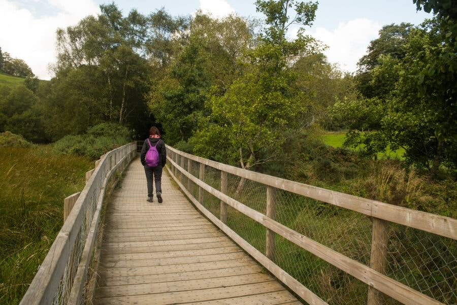
Plitvice Lakes National Park – Croatia
A network of trails through a Croatian watercolour painting. Wooden boardwalks wind between cascading turquoise lakes and countless waterfalls—pure magic.
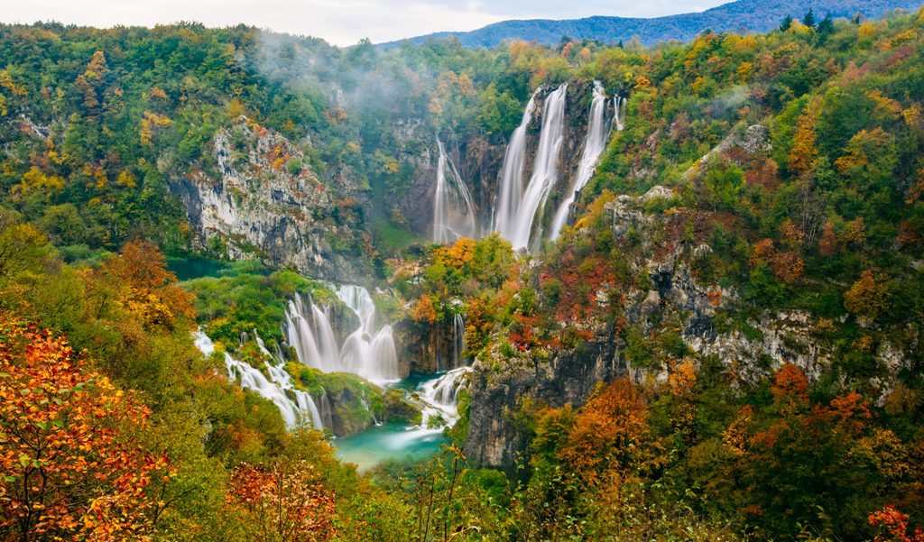
What to hike
A UNESCO-listed network of 16 terraced lakes connected by waterfalls and boardwalks. Trails are waymarked into circuits (A–K), ranging from 2–8 hours.
Difficulty
Easy walking on maintained paths and wooden walkways. Prime season: Year-round; summer is busiest.
Logistics
Buy timed tickets in advance; no swimming is permitted. Arrive early to avoid crowds and secure parking.
Alpe Adria Trail – Austria, Slovenia, Italy
A uniquely cultural long-distance path linking three countries, leading you from glacial Alps to the Mediterranean coast through vineyards and charming villages.

What to hike
A 750 km in 43 stages from the Grossglockner area (Kaiser-Franz-Josefs-Höhe/Heiligenblut) through Carinthia and the Soča Valley in Slovenia to Muggia near Trieste. Pick iconic sections: Stage 1–3 around Heiligenblut, Soča River stages (Kobarid–Bovec–Trenta), and the Karst plateau into the Adriatic. Typical day stages: 17–25 km.
Difficulty
Easy to moderate; well-waymarked mixed terrain (forest tracks, riverside paths, foothills). Cumulative fatigue and occasional steep, rocky or exposed sections. Prime season: May–October; snow possible early/late near Grossglockner.
Logistics
Strong infrastructure with booking/luggage transfer services on many stages; frequent accommodation in villages/towns. Carry sun protection and sufficient water on Karst sections; rain layers for alpine stages. Public transport connects major hubs (Villach, Kobarid/Bovec, Trieste). Cross-border route—carry ID and confirm current trail advisories; use official GPX for navigation.
Pennine Way – England, UK
Embark on Britain’s gruelling and moody backbone, a 268-mile test of spirit across peat bogs, remote moors, and the wild beauty of the North. Passing through Northumberland, Yorkshire and Derbyshire.

What to hike
A 431 km National Trail from Edale to Kirk Yetholm, following the moorland “spine” of England into the Scottish Borders. Typical time: 16–20 days.
Difficulty
Strenuous; sustained ascents, boggy sections, and frequent rough weather. Navigation skills help on exposed uplands. Prime season: May–September.
Logistics
Book accommodation ahead in popular stretches; baggage transfer services operate along much of the route. Gaiters and waterproofs are highly recommended.
Hadrian’s Wall Path – England, UK
Walk through centuries of history along this Roman frontier, where the rolling green landscape of Northern England is punctuated by ancient Roman forts and milecastles.
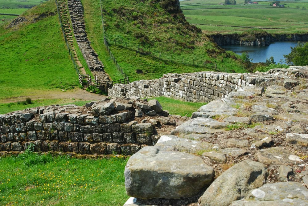
What to hike
A 135 km coast-to-coast National Trail broadly following the Roman frontier from Bowness-on-Solway to Wallsend. Typical time: 6–8 days.
Difficulty
Moderate well-waymarked rolling terrain. Prime season: April–October; expect wind exposure on ridgelines.
Logistics
Excellent public transport links and baggage transfers; museums and forts en route. Book lodging near the central, busier sections.
Snowdonia/Eryri – Wales, UK
A hiker’s playground of dramatic valleys, razor-edged ridges, and misty peaks, crowned by the challenging yet popular ascent of Mount Snowdon itself.
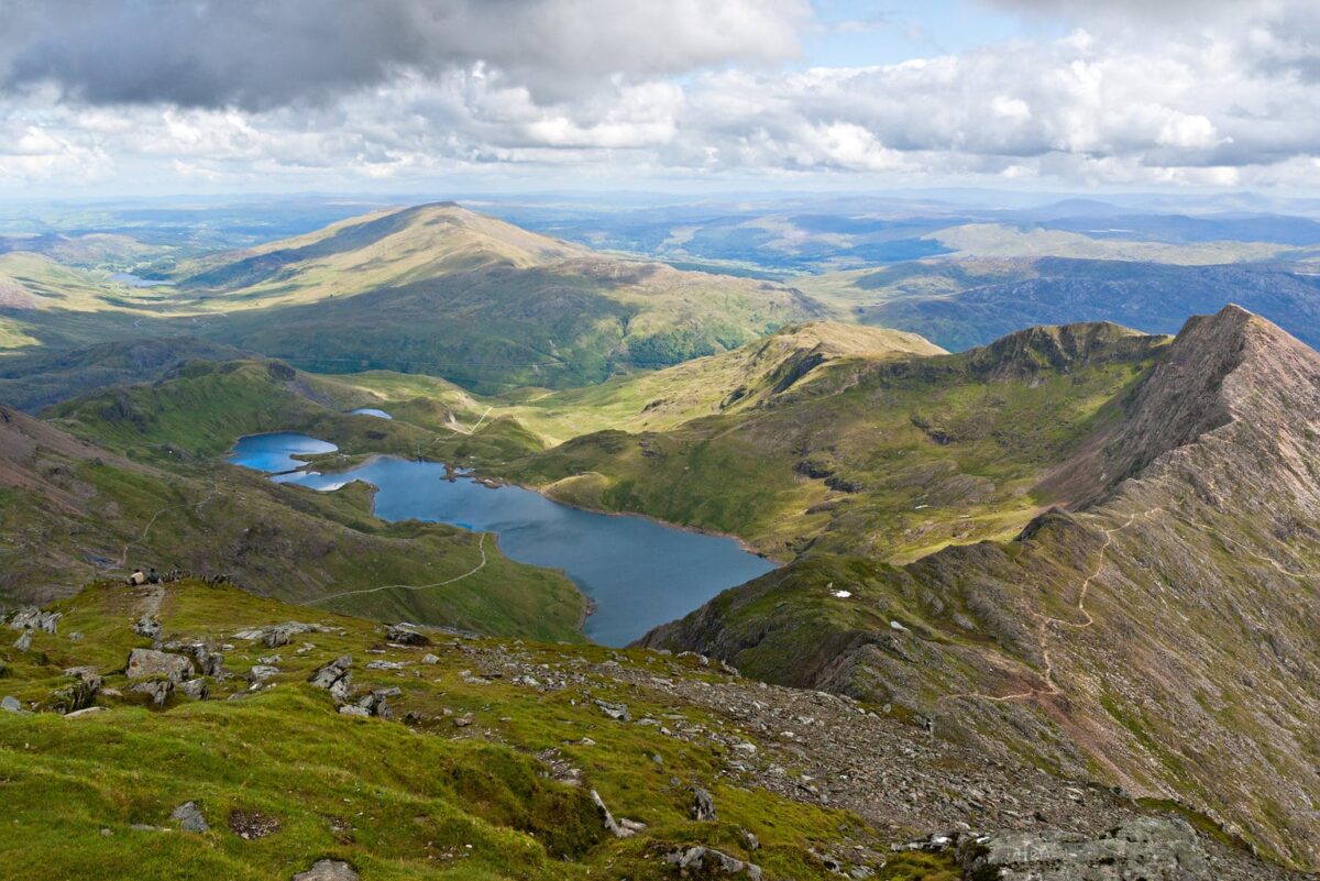
What to hike
Yr Wyddfa/Snowdon via Pyg–Miners (10–12 km; ~700–900 m gain; moderate, very busy), quieter routes like the Ranger Path; Tryfan North Ridge (Grade 1 scramble; exposure), Glyderau loop for rugged terrain.
Difficulty
Moderate to strenuous; scrambling and exposure on select routes. Prime season: May–September (full winter kit required outside this window).
Logistics
Start early to avoid crowds; check Met Office mountain forecasts; carry map/compass and full waterproofs. Parking fills quickly—use park-and-ride where available.
Wicklow Way – Ireland
Follow forest tracks and remote mountain paths through the “Garden of Ireland,” a lush green escape surprisingly close to Dublin.
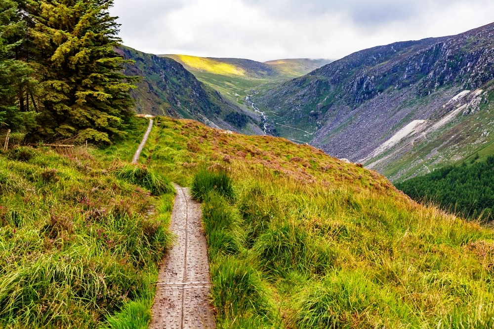
What to hike
A 130 km waymarked trail from Dublin’s foothills through Wicklow uplands to Clonegal. Typical time: 5–7 days; popular for short sections near Dublin.
Difficulty
Moderate steady gradients on forest tracks and open moor. Prime season: April–October.
Logistics
Easy access via Dublin transport; lodging available in villages. Expect wet conditions and occasional bog—use waterproof footwear.
Kerry Way – Ireland
Immerse yourself in Ireland’s postcard-perfect southwest on this long-distance loop, winding through the legendary Lakes of Killarney and along the wild Kerry coastline.

What to hike
A 214 km loop of the Iveragh Peninsula with Wild Atlantic Way views and rugged valleys. Typical time: 9–12 days.
Difficulty
Moderate to strenuous; remote, exposed stretches and variable trail underfoot. Prime season: May–September.
Logistics
Waymarked; book B&Bs/guesthouses in advance during summer. Pack for persistent rain and wind; carry layers and a reliable map/GPX.
Causeway Coast Way – Northern Ireland
A spectacular coastal walk linking the otherworldly Giant’s Causeway with rugged cliffs, Dunluce Castle, sandy strands, and ruins steeped in myth.
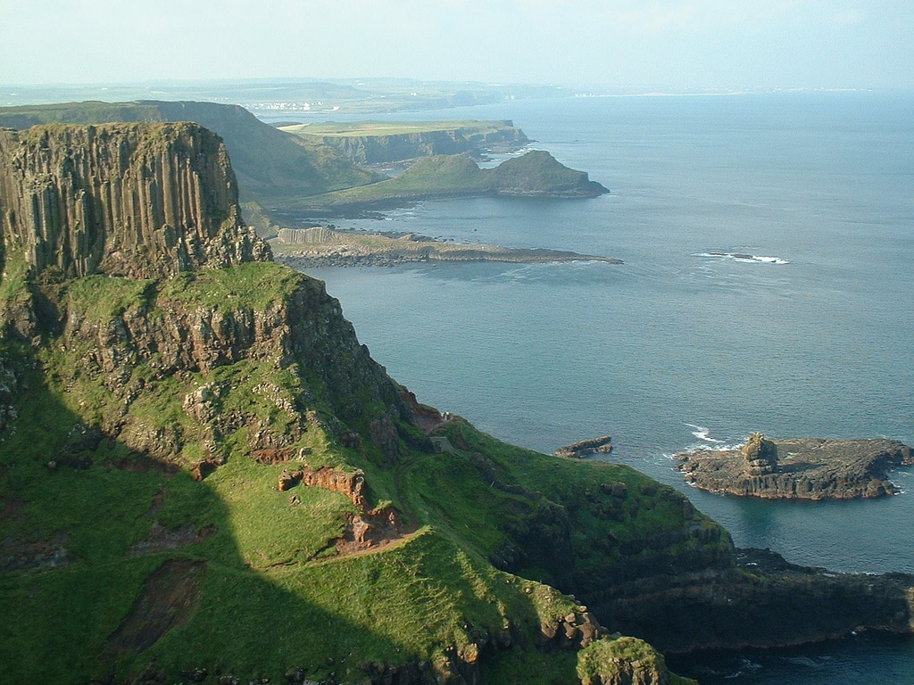
What to hike
A 51 km between Portstewart and Ballycastle, linking cliffs, beaches, and the Giant’s Causeway. Typical time: 2–3 days or split into day hikes. Your starting point can be either location.
Difficulty
Easy to moderate; mostly well-defined coastal paths with some sand and rocky sections. Season: Year-round; strongest winds and storms in winter.
Logistics
Check tide/wind conditions; good bus links along the coast. Visitor Centre tickets are optional—paths remain open, but keep a safe distance from cliff edges.
Responsible hiking checklist

- Season-appropriate layers, waterproofs, and sun protection
- Map/GPX and familiarity with local trail signage
- Sufficient food and water; treat sources where appropriate
- Emergency kit: first aid, headlamp, whistle; in alpine zones consider helmet and via ferrata kit
- Respect local regulations, hut bookings, and Leave No Trace principles
- Verify current conditions on official park/route pages before you go
How we selected these hikes

As most of my readers know I don’t hike as I’m mobility challenged but I do love a good walk. My son put these hikes together as he is a bit obsessive and loves a good hike.
He prioritized routes with:
- Established waymarking and hut infrastructure
- Clear difficulty grading and typical durations
- Reliable official information (national park pages, route associations, alpine clubs)
- Distinctive landscapes and cultural value (UNESCO listings, historic routes)
- Seasonal feasibility for non-technical hikers
Primary references include national parks authorities, trail associations (e.g., West Highland Way, TMB), and local guiding services; always verify current conditions on official sites before travel.
Permits, reservations, and access

Huts and rifugi (Dolomites, Triglav, TMB, Monte Rosa): Reserve months ahead in peak season.
Timed tickets (Plitvice): Buy online in advance; arrive early for parking.
Guides required/recommended
Via ferrata (Dolomites, Triglav summit ridge), glacier-adjacent terrain (Monte Rosa variants), technical ascents (Mont Blanc summit).
Trailheads and transfers
West Highland Way: Start Milngavie; rail from Glasgow.
Laugavegur: Bus to Landmannalaugar; shuttle from Þórsmörk.
TMB/Tour de Monte Rosa: Access via Chamonix, Courmayeur, Zermatt; local buses/cable cars shorten approaches.

Insurance
Consider mountain rescue coverage (e.g., Alpine club membership or travel insurance that-altitude trekking).
Seasonal and safety essentials
Weather: Alpine and coastal systems change rapidly; carry waterproofs and warm layers even in summer.
Altitude
Expect multiple passes above 2,500–2,700 m on TMB/Monte Rosa; pace days, hydrate, and know AMS symptoms.
Crowds
Peak July–August; start early, use shoulder seasons (late June, early September) where conditions allow.
Emergencies
Save local rescue numbers and enable offline maps/GPX; carry a whistle and headlamp. In remote Balkan karst, plan water carries and resupply ahead of time.
In conclusion, whether you seek a few inspiring hours or a life-altering journey, Europe offers an unmatched tapestry of hiking trails. From the breathtaking coastal paths of the Cinque Terre to the rugged, miles-long stretches of Scotland’s Highlands, the continent’s beautiful hiking trails cater to every ambition.
Your favorite hiking memories may be forged on accessible day hikes Europe is famous for, or on epic multi-day treks that connect villages and cross borders. Ultimately, the diverse hiking trails and destinations Europe proudly preserves ensure that every step on a beautiful European hiking trail is a step into adventure, making your hikes Europe an experience you will treasure for a lifetime.